


Signpost 11
Signpost 11 is on Barley Lane, one of the original roads out of Hastings, shown on old maps of 1783 and 1813. It’s now part of the long distance cycle path, National Route number 2, from Dover to St Austell in Cornwall. Visit Sustrans, which is a charity which encourages people to travel by foot, bike or public transport, for more information on National Route number 2.
The view to the West, looking down the lane, is towards Eastbourne, Beachy Head and The South Downs National Park.
The Country Park is within the High Weald Area of Outstanding Natural Beauty.
Between signposts 11 and 19 you will pass Fairlight Place which is set back from Barley Lane. This is probably the most significant historic building in the Country Park. Steve Peak’s The Hastings Chronicle (look for the section "Mid-16th Century") dates the original part of the house as being from the mid-C16th to the mid-C17th.
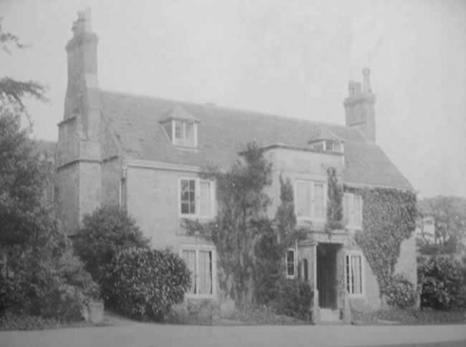 Fairlight Place in late Victorian times - Thanks to Steve Peak - The Hastings Chronicle
Signpost 13
Signpost 13 is on the access roadway from Barley Lane into Fairlight Glen, which was built by Hastings Council as part of the 1951 agreement with Major Sayer, the existing landowner, when the glens and cliffs were purchased by the Council.
The fields on either side of the track form part of the Country Park and are managed so as to encourage bio-diversity and benefit wildlife.
In Fairlight Glen, which is below you to the East, mines had been hurriedly laid in the summer of 1940, because of the threat of invasion. Accurate records of the location of some of the mines was lost because the officer in charge was carrying the plans when he was blown up by stepping on a mine displaced by a German aircraft’s bombing of the glen.
Close to this signpost, The Bomb Disposal unit of The Royal Engineers set up camp in January 1956 and worked for two years to clear the minefield on, and near, the beach at the bottom of Fairlight Glen.
This was the second attempt by the unit to clear the mined area. After the Second World War they swept a length of land adjoining the seashore about two miles long and 200 yards deep. By January 1948 this had all been cleared, except for the portion below the cliff, which was known to contain beach mines, and it was fenced off. The cliff behind this had been hit by a V1 flying bomb, bringing down a large portion of cliff on the mines, and it was hoped the mines would be buried for ever. But from 1953 onwards some mines had been found on the beach, plus one in the glen, so part of the glen was also swept clear.
All the mines found were blown up.
Signpost 15
The Dripping Well
Fairlight Glen starts close to this signpost. The stream forms a small waterfall that has been a popular tourist destination since Victorian times. In the 1920’s, where the path widens, above the waterfall there was a tea hut.
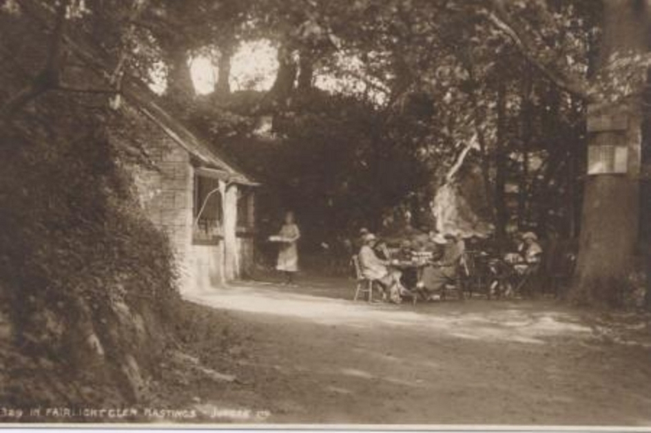 Postcard of tea shop by the dripping well in Fairlight Glen, 1920s. Judges Postcards
Woodland
The trees in Fairlight Glen have not been planted but have regenerated naturally.
Television
In 1922 Scotsman John Logie Baird (1888-1946) came to Hastings to recover from a severe illness. He later recalled: “ I went for a long walk over the cliffs to Fairlight Glen, and my mind went back to my earlier work on television. Might there be something in it now?” Back in Hastings he, together with a friend, put together a mechanism that transmitted the first ever television pictures.
Smuggling
In 1831 there was, in bright moonlight, an encounter between smugglers and coast blockade men (armed customs officers). At least two smugglers died, from a gang of 100, and the incident confers on Fairlight Glen the dubious distinction of being the location of one of the final fatal encounters of the smuggling era.
Signpost 16
Fairlight Glen
This signpost is near to the bottom of the glen.
Paths
From here the glen can be climbed either by the path that follows the stream or by the wider path that was cut by The Royal Engineers in 1956-58 as part of the process of removing mines laid in the Second World War (1939-45)
It is also possible to climb down to the "clothes optional" beach by following the path by the stream. The cliffs in this area are eroding all the time and this path has been closed by the Council. It’s not maintained and can be dangerous.
If you wish to return to Hastings you can continue along the Saxon Shore Way Westwards.
Birds
Until the 1890’s Ravens nested on the cliffs to the west, between Fairlight Glen and Ecclesbourne Glen, one of the last nesting sites in Sussex. Herring gulls, cormorants, kestrels, jackdaws, pigeons and some fulmars roost on the cliffs.
Signpost 17
Fairlight Glen is below you.
If you look across the glen to the West you may recognise a famous view painted by William Holman Hunt in 1852.
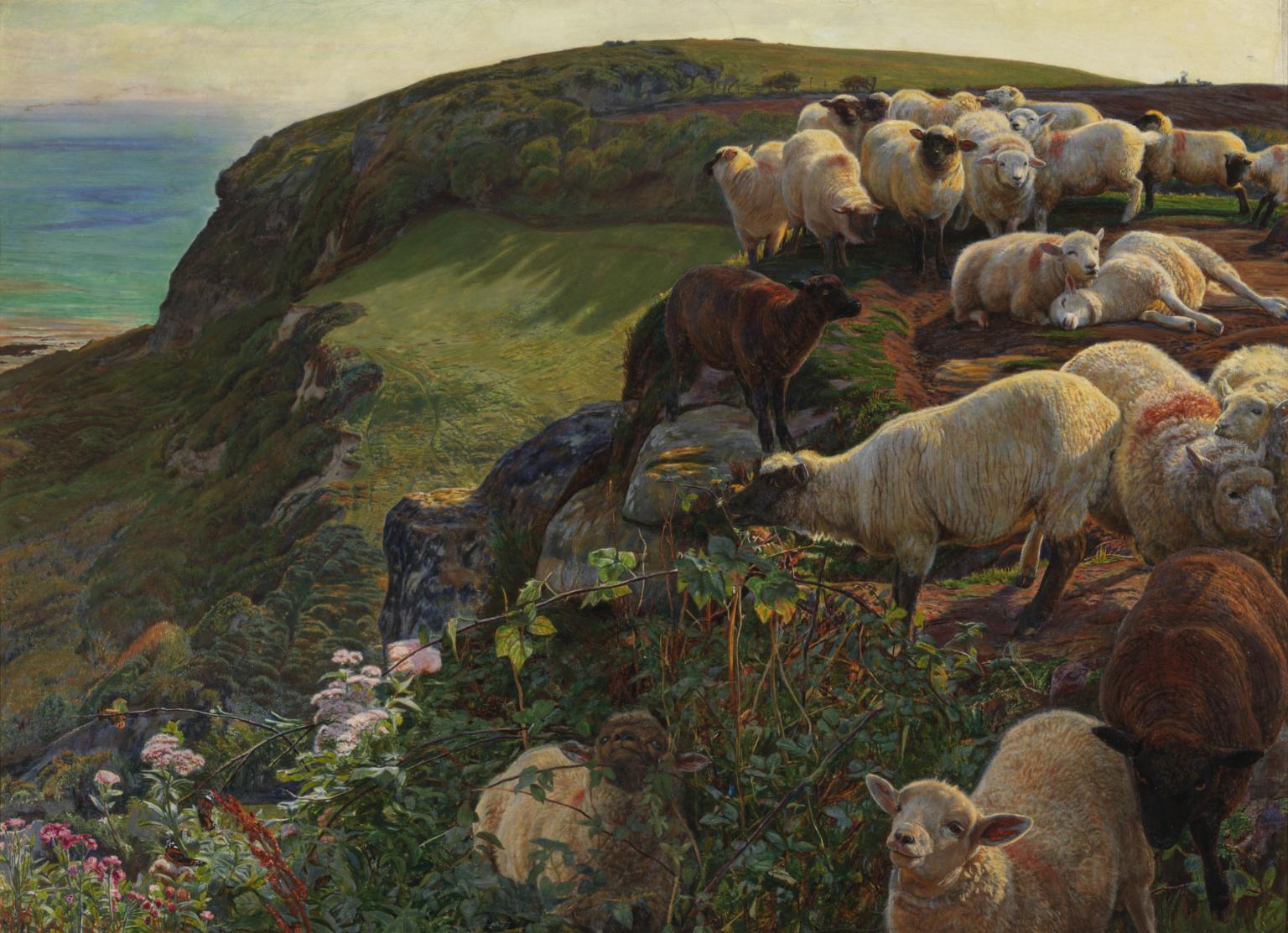 William Holman Hunt; Our English Coasts, 1852 ('Strayed Sheep'); CC-BY-NC-ND 3.0 (Unported), Photograph © Tate, London 2016
The painting “Our English Coasts”, later known as “Strayed Sheep” is in the Tate Collection (click here for more information). Then aged 25, Hunt had heard of Hastings through one of his pupils, Robert Martineau, whose parents were living at Fairlight Lodge (on the corner of Martineau Lane). Holman Hunt and John Millais stayed and painted at Fairlight Lodge.
Signpost 18
Location
The 1908 OS map below shows where Lovers' Seat used to be and the cliff edge as it prevailed in 1908. On top of this map Steve Peak has drawn the situation as Google maps showed it in the autumn of 2014 showing clearly how much cliff has been lost. Steve has drawn the current cliff edge in pink, the fence near the Seat in red, and paths nearby in blue.
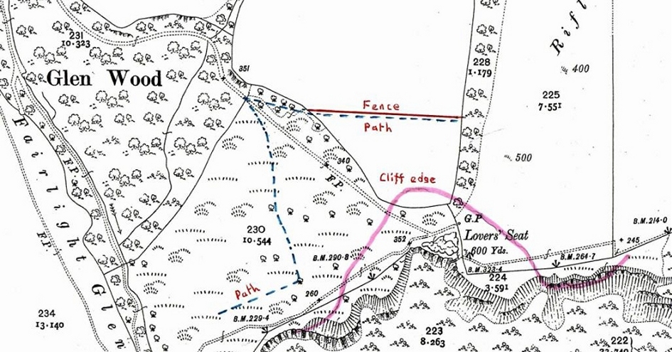 OS Map (1908) showing Lovers’ Seat marked to show the speed of cliff erosion in this area - Ordnance Survey
 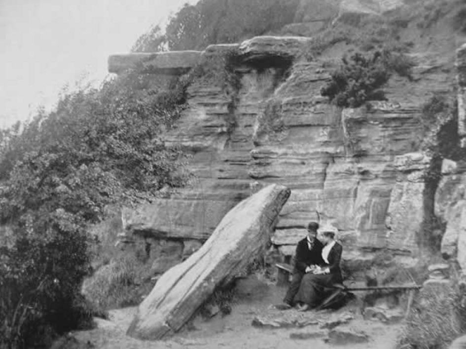 Lovers seat in the 1890’s - Steve Peak The Hastings Chronicle
What you can see on a fine day in the far distance, to the East, is the shingle bank of Dungeness with its nuclear power station. On an exceptionally clear day you may be able to see France.
The remains of two old firing ranges can be seen from here. On the seaward side of Signpost 18 there is a high bank which was part of a rifle range which was in use during the Second World War (the early 1940’s). Older ranges in the glen which were constructed in 1862 and 1901, stretched across the valley (firing up the glen), and were probably used again during the Second World War.
Plants
Between Signposts 18 and 19 the path has pasture on the east side and a wooded area, Brakey Bank, on the west. In the pasture on the east side, the site of the 1862 and 1901 rifle range, you may find ling and bell heather. There is also wood sage (July – September). Brakey Bank (“Brake” is a local word for bracken) has a large variety of plant species and woodland trees. The trees are mainly oak, ash, field maple, hazel, sycamore, holly, blackthorn, and elder. As Brakey Bank faces east it catches the morning sun and is a good location to view insects basking in the warmth.
Oak is considered by many naturalists to be Britain’s most important tree because of the large number of animal and plant species associated with it. Over 300 species of insect feed directly on oak which in turn form the food of other insects and many birds. You will see that some of the trees here support a considerable growth of ivy. This plant climbs the tree by means of modified roots which form adhesive suckers but contrary to popular opinion cause little or no damage to the tree. Notice that only the lower leaves have the typical lobed shape.
It can be seen that some of the trees on the bank, especially the sycamore and hazel, have been coppiced. This is a traditional management technique where trees are cut to ground level and the stump then allowed to regenerate producing many new shoots which can be cut every fifteen to twenty years to provide a supply of timber suitable for fencing and tool handles. Coppicing has not been used in this area probably since the 1970’s except for an area of sycamore that was cleared in 2016.
The sycamore is alien to Britain, introduced some four hundred years ago, and supports few insect species. The large leathery leaves lie in a slowly decaying mass beneath the trees and this prevents many plants from growing beneath them. It is an invasive species and able to grow in exposed situations and has grown prolifically in this area. You may notice large black patches on the leaves which are caused by the tar-spot fungus.
Beneath the trees you will see bluebells (April – June), wood anemone (March – April), red campion (May – July), greater stitchwort (April – June) and yellow archangel (May - June). There are also ferns including the soft shield fern, male fern, broad buckler fern, and on the rock outcrops the common polypody which has much less divided leaves than other ferns.
Birds
Yellowhammers and Bullfinches are frequently in this area and in autumn you may see Stonechats and Wheatears. Herring gulls, Kestrels, Peregrines, Jackdaws, Pigeons and some Fulmars can be seen on the cliffs.
Signpost 19
Warren Glen is below you.
Warren Cottage, which is opposite where you are standing, in the trees, was previously used as the headquarters for the Country Park Rangers but is now privately owned. On the top of the hill opposite, Fairlight Head, are the former Coastguard Cottages and the radar scanner. For more information about Fairlight Head see information for Signpost 24.
Land Management
At this location you are at the dividing line between the land in the glen where there is rough grazing and the more intensive farmland above.
In the glen is a mixture of pasture, woodland, bracken and gorse. Animals that thrive in this environment, such as Exmoor ponies and some cattle, have been introduced to maintain bio-diversity.
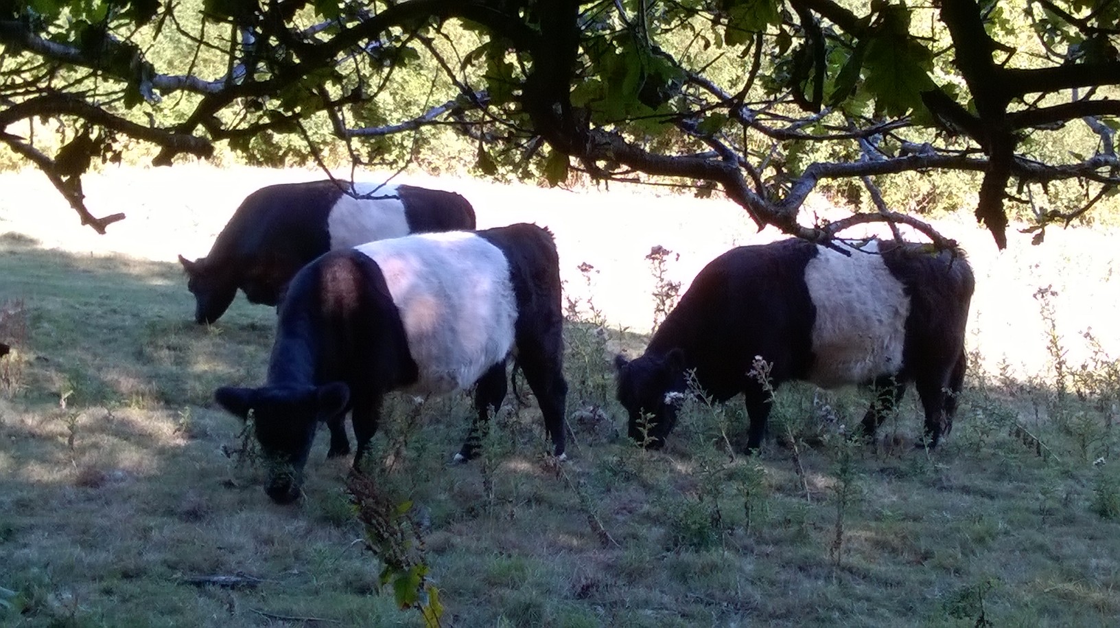 Belted Galloway cattle grazing in Warren Glen © Michael Moor, August 2018.
Birds
As well as being one of the best places in the country park for nesting Yellowhammers and Whitethroats, the top of Warren Glen is an excellent place for autumn migrants; they can be seen passing in large numbers in early morning from here, and newly arrived Wheatears, Whinchats and Redstarts rest on the short turf and fences. Scarcer birds can also be found in autumn; look out and listen for Ring Ouzels in October. This is a very good place to scan the skies for raptors such as Buzzard, Kestrel, Sparrowhawk and Peregrine, and to check the Wood Pigeon flocks for the smaller Stock Dove.
Signpost 20
Location
You are standing about 140m above sea level and you are above Warren Glen. There is more information about the Glen on the information sheets for Signpost 18 and 19. The direction arrow on the Signpost points you to the quarry.
The Quarry
1. Geology
The sandstones from the Ashdown Beds which are well exposed in the quarry have been dated to around 130 million years old and are among the oldest rocks to be found in South East England.
2. Quarry workings
The quarry’s main period of activity was during and immediately after World War 2 (from 1939 to 1951). The sand produced by the quarry was of very fine quality and was used for making glass for optical instruments. The sand processing plant was where the large car park is now on Lower Coastguard Lane.
In the quarry there is a windowless brick building with a concrete roof which may have been used as an air-raid shelter in the Second World War, or a blast shelter for workers using explosives in the quarry.
Plants
On the steepest faces of the quarry the only plants that can grow are lichens and algae but in the crevices a small amount of soil has accumulated and mosses and grasses have become established. Where more soil has collected herbaceous plants and gorse grow. In 2015 some of the gorse was cleared to allow space for other plants and lichen.
The floor of the quarry is uneven due to the spoil left from the quarrying operations and the turf is short from being grazed especially by rabbits. Birch, holly, willow and hawthorn are growing here as are gorse, bramble, red and white clover, birds foot trefoil (flowers June to August), hop trefoil (June to August), yarrow (June to August), spear thistle (July to September) and smooth hawksbeard (June to September).
Birds
Birds such as Goldfinch, Linnet, Chaffinch, and Yellowhammer may be seen.
Bees
In places in the rock faces of the quarry, and on bare sandy paths in summertime, you may notice holes dug by bees. These are the entrances to nesting tunnels constructed by some species of mining bee.
Signpost 21
Location
From here Warren Glen rises from where you are standing, at about 30 metres above sea level, to about 150 metres at the top of the glen. The stream runs through the central wooded area fed by springs in the valley.
In the 1870’s and 1880’s the water from this stream together with that in Fairlight Glen was piped to Hastings along the coast. There is evidence of this higher up the stream where a small collection pool can still be seen (restored in 1990).
Geology
The Crags and steep ground around the Glen are formed of Ashdown Sandstone whilst the lower ground is “Fairlight Clay”. Below the cliffs the wave cut “Fairlight Clay” rock outcrops are well exposed at low tide.
The cliffs are eroding and the cliff edge area is very dangerous.
The headland to the West (your right facing the sea) is capped by a massive outcrop of Ashdown Sandstone.
Birds
This is the closest you will get to the sea, so look out for Sandwich Terns and Fulmars in summer, and Common Scoters, Great Crested Grebes and Red Throated Divers in winter. In the scrub and nearby woodland you may see migrants such as Willow Warblers and Chiffchaffs, and singing Whitethroats in summer. The green woodpecker occurs in the wood along the stream and betrays its presence by the echoing laughter like call, hence it is often called the “yaffle”.
Plants
Alders and sallow willows grow along the stream.
Signpost 22
Location
Below Signpost 22 is the Warren Glen stream.
Birds
Look out for Sparrowhawk and Buzzard over the woods.
Plants
The area around the stream below is damper and cooler during the summer and more protected from frost during the winter than the surrounding land. Consequently it has a microclimate that resembles the oceanic climate of the West coast of Britain which between 5,000 to 3,000 BCE was characteristic of the whole of Britain. This feature is reflected by the presence of certain mosses and liverworts in Warren Glen which are more or less confined to Western Britain today but which, it is thought, had a more widespread distribution some 6,000 years ago. Their continued existence here depends on the maintenance of the tree canopy in order to retain the high relative humidity and give continued protection from extremes of temperature. Many ferns, rushes and sedges such as the pendulous sedge with its large nodding flower heads grow here.
Animals
The large expanse of bracken is a good area for adders. The female adder is usually brownish whereas the male is greyer, both having a darker zig-zag marking down the back. If you see an adder do not approach too closely, they are not aggressive but are best left alone.
You may also see common lizards here.
Moths and Butterflies
Typical butterflies of this area include the small tortoiseshell, common blue, and migrating red admiral and painted lady butterflies, hedgebrown, small copper, speckled wood, small skipper, green hairstreak, and large white. You may also see the Speckled Yellow day-flying moth.
Signpost 23
History
You are standing above Warren Glen and beyond is Fairlight Glen and Ecclesbourne Glen. 215 acres of these glens was acquired by Hastings Council from Major Sayer, the private landowner, in 1952. There had been a formal handing over of the title deeds, in the presence of Princess Elizabeth (Queen Elizabeth II), the previous year.
By adding this land to its existing property the Council owned all 2.9 miles of the cliff area between Tackleway, in Hastings Old Town, and the East end of the Firehills.
Whilst the price paid was only £10 the Council took on the substantial responsibility for maintaining the land including the coastal footpaths.
Steve Peak says in The Hastings Chronicle (look for the section "1949 July 25"):
“Major Sayer was disposing of the steep glens and cliff edges that were unusable as farmland and expensive to maintain, and much of which were also to be designated as protected environmental sites in the coming years. So the Major, an astute businessman ... negotiated strict conditions on the conveyance that required the council to fence off the steep glen sides and cliff edge, divert several paths and create a new vehicle access track into Fairlight Glen from Barley Lane (which today is the only such access). After this work was carried out, the farmland that he retained was to be safer for cattle and with restricted public access, enabling him to use it more intensively and therefore more profitably.”
Animals
In Warren Glen you may see ponies or cattle roaming. The Rangers use these animals to maintain the varied habitat of the Glen by keeping the bracken, bramble, and gorse under control.
Birds
The large areas of gorse are nesting sites for Linnets and Whitethroats.
Signpost 24
Location and Coastguard
The high promontory of Fairlight Head has been important for many centuries as a lookout over the English Channel, and a position from which “line of sight” messages could be sent along the south coast.
Signalling was by fire beacon in the 16th century, especially at the time of the Spanish Armada in1588. In the late 18th century the war with France led to the setting up of a ‘Signal Station’ in 1795, where the Coastguard Cottages are today. The station was a prefabricated wooden hut, with a 25 metre high signal mast displaying flags and signal balls, which communicated with the next signal stations, on Dungeness Point, in the East, and Galley Hill to the West.
Strong fears of a French invasion in1803 led to the setting up of an inland signalling system on top of Fairlight Down, where North’s Seat is today.
In 1818 a more substantial building replaced the signal station hut and a new semaphore signalling system was started. It was run by the Coast Blockade Service, created in 1817, which was renamed the Coastguard in 1822. The Fairlight Coastguard station was rebuilt in 1904 with the buildings which are today the Coastguard Cottages with lookout facilities on the seaward end of the building. In 1927 Fairlight became the only constant-watch Coastguard station between Newhaven and Dungeness.
The cliff top location continued to be a vital lookout point into the 20th and 21st Centuries. The map below shows the proposed 1940 German invasion routes from occupied France, across the Channel. Fairlight is at the centre of the invasion beaches which stretched from Hythe to Brighton. The initial objective line is in red.
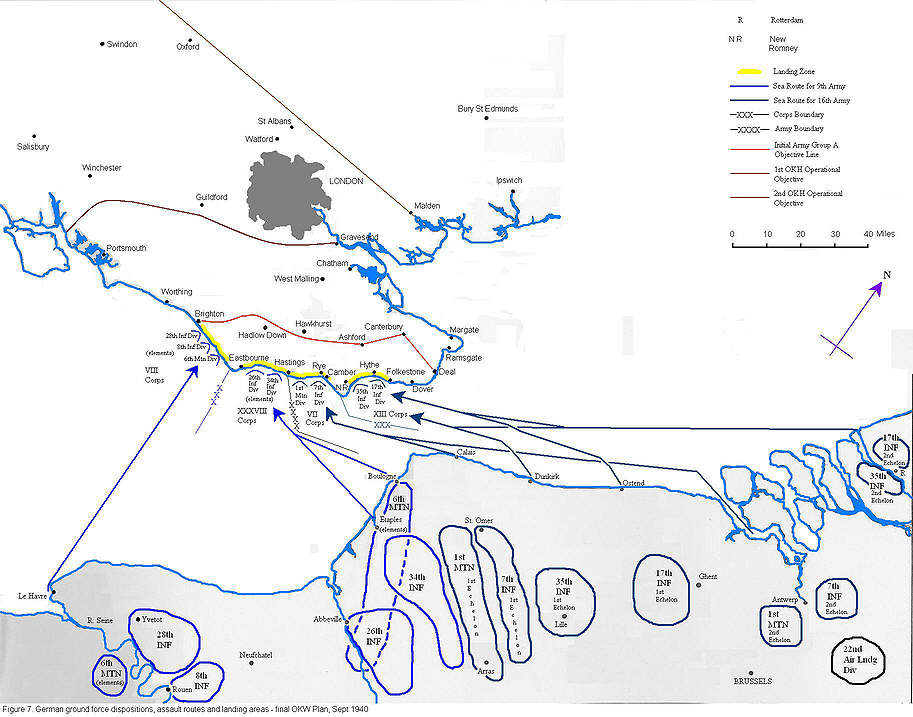 Antill, P., (20 October 2010), Operation Sealion Figure 7: Final German Invasion Plan
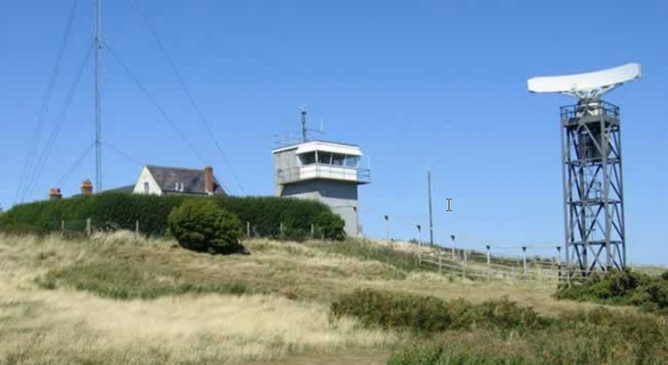 Fairlight Coastguard Station - Steve Peak 2009
From Signpost 24 you can see to your left, facing the sea, Dungeness Point with its Nuclear Power Station. On a clear day it’s possible to see the French coast.
Radar
In 1940 a radar station was established on Fairlight Road to warn of the approach of enemy bombers. In 1952 it operated to counter the perceived threat from the Soviet Union. An associated underground technical centre was built next to Fairlight Coastguard station in 1952. This large underground bunker, although redundant by 1956, still exists. On top of the bunker there was an entry guard house looking like a suburban bungalow.
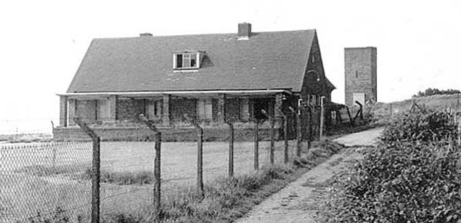
The Guardhouse in 1968 https://www.subbrit.org.uk/rsg/sites/f/fairlight/The surface buildings were demolished in 1973 but the raised area of land to the south-east of the current radar is the outline of the bunker. There is also a small Royal Observer Corps bunker, built in the late 1950’s, close to the current radar which would have been manned by three volunteers in the event of a nuclear attack to monitor the effects of the explosion. The current radar, first located here in 1995, operated by “The Channel Navigation Information Service”, is tracking shipping movements in the Channel to ensure ships comply with the shipping lanes. From Fairlight the ships you are likely to see will be travelling West as this is the lane closest to this coast. Real time information showing the ships maybe seen on the ShipAIS website.
Saxon Shore Way
The coastpath forms part of the long distance Saxon Shore Way which goes from Gravesend, on the outskirts of London, to Hastings.
Birds
This is an excellent place from which to observe the autumn migration.
Moths
The six-spot, a day-flying moth, makes its cocoon in the grass in this area.
Signpost 25
Firehills
The Firehills, the land between Fairlight Head and Fairlight village, were purchased by Hastings Council in 1927 to prevent the Fairlight Cove development spreading Westwards.
Biodiversity
The Country Park includes the Hastings Cliffs Site of Special Scientific Interest (SSSI), and the European-designated Special Area of Conservation. These recognise the national and international importance of the vegetated cliff, cliff top grassland and coastal heathland which characterises the Country Park and, indeed, makes it so special.
The council is working with Natural England on the management and protection of the Country Park and, in 2013, both bodies entered into a second 10 year agreement; known as a Higher Level Stewardship Agreement. The agreement highlights the fact that gorse and bracken are a severe threat to maritime heath and cliff-top habitats and their control has to be high priority, and the agreement sets very clear targets for their management.
The work of gorse clearance ensures that the unique nature of the Country Park is maintained - reducing the dominant gorse and scrub will increase the land available for less dominant plants, benefit wildlife and ensure that the landscape continues to look attractive, with its distinctive mosaic feature, and also enhance the coastal view.
Birds
This is one of the best places to see the sometimes spectacular early morning bird migration in autumn ( September - mid November ). Look out for hundreds of Meadow Pipits, Swallows, House Martins and various finches passing at close range. Also in autumn look out for Wheatears, Stonechats and Whinchats in this area.
In spring and summer, Whitethroats and Yellowhammers can be seen and heard singing.
At any time of year those with binoculars should spend time scanning the sea for rather distant seabirds such as Cormorants, Great Crested Grebes and Red Throated Divers, and be alert for passing Peregrines and Ravens.
Signpost 27
Above Signpost 27 you will see the remains of a concrete structure built, in 1927, by the Coastguard as a lookout. The framework of the original building can be seen from this 1987 photo.
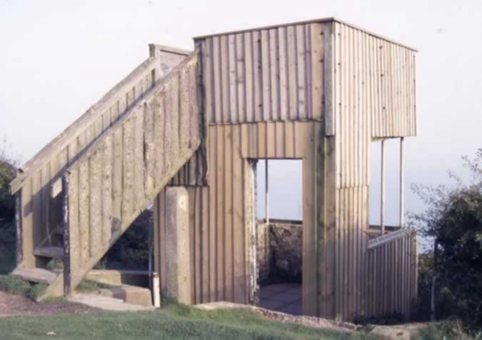 The 1927 lookout as it looked in 1987 - Steve Peak The Hastings Chronicle
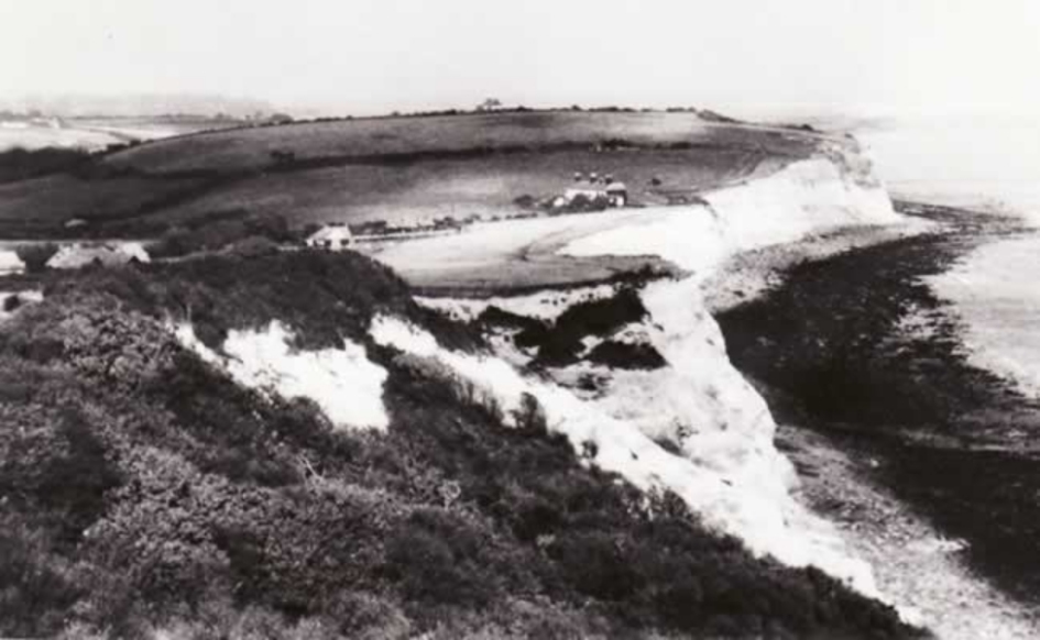 Fairlight Cove just as development started - Steve Peak The Hastings Chronicle
Whilst there was some very limited housing development in Fairlight before the First World War (see Haydon Luke Fairlight: A Sussex Village by the Sea p81) large scale development started after an auction of farms and farmland in 1921. The start of housing development prompted the purchase of the Firehills (the land between Signposts 27 and 24) in 1927 by Hastings Council to stop development spreading West towards Hastings.
By the start of the Second World War, in 1939, about 100 houses had been constructed. Development continued after war and continues today.
Plants
Look along the boundary fence between the Country Park and the gardens of the houses. It’s interesting to see how plants will spread; in this case garden bamboo has now spread into the Country Park.